Tuesday 28 February 2006

Day 6

Sunday February 26th - Glengarriff to Kenmare - 64 miles - Total so far 486 miles

From My Pictures


After yesterday my body was really complaining with the prospect of another day in the saddle. A lot of this was psychological because throughout the previous day I had been looking over at the various peninsulas of Bera and Kerry looking at the mountains knowing that I had those to look forward to.

My knees were good and the combination of wearing the knee pads and increasing my cadence had meant that they were completely without pain. My chest also had faired well enough and today I made sure that this would continue by wrapping a tee shirt around my upper body. Main problem were saddle sores so I liberally applied some creams.

No early breakfast was available so I got around this by arranging to take a cold breakfast to my room. As the bathroom was unheated this made an excellent fridge (yes it was cold) and I had the greatest of pleasure of waking at 6.30 on a Sunday morning eating my Weetabix in a room smelling like the inside of a locker (yes unwashed cycling gear, that I had to wear for a second day, isn't the most aromatic).

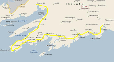
Today I was doing the Bera peninsular and even though I was dreading it I was also looking forward to some stunning scenery and I wasn't to be disappointed.
With far less traffic than the peninsular to the North, Bera's awesome rugged landscape and colourfully painted villages make it a special place to ride

There is something magical that I love about cycling at dawn. The roads are empty, the world is asleep and I go for hours without seeing anybody except the occasional farmer or some hapless person on an early shift. The Irish villages and towns gradually come awake around the tim to go to mass and then you have to dodge the people standing in the middle of the road chatting and catching up. You also get views like these:

In the heart of the touristy southwest, it's suprisingly lowkey, overshadowed by the famous Ring of Kerry on the nieghbouring Iveragh Peninsula. It's in Beara's villages that you might find an entire community filling the low ceilinged pub after a funeral, or the shopkeepers daughter explaining the legend of a local landmark. Tour buses are rare and the Irish as much as visitors come here to relax

The dramatic mountainous core of the Beara Peninsula is a rocky sandstone glacier carved spine. Such an imposing barren landscape might seem inhospitable, were it not for the lushness of the valleys below. Colourful fushias and rhododendrons are everywhere (though not in February!!). The 300 hectare oak woodland, Glengarriff Woods Nature Wood Reserve, at the peninsula's eastern end, features Atlantic species including St Patricks cabbage, kidney leaved saxifrage and the strawberry tree. The mild climate also encourages the growth of mosses and ferns. Similiar forest once covered a greater area, but was extensively cut during the 17th century to produce charcoal for iron smelting.


The start of the ride was quite a climb but well worth the amazing views out across the water to my left with the rugged mountains to my left. Knowing that I was going around the mountains was somewhat of a relief as they looked very daunting, also knowing that I wouldnt be going over the Healy Pass was a great relief though I am sure I was missing a wonderful climb. The Sugarloaf Mountain dominated the early ride and gradually receded only to be replaced by Hungry Hill (now where did that name come from?) after leaving the little sleepy village of Adrigole.

The peninsula's cragggy spine dominates early on; the views unfold during the first of the rides three long climbs, beginning less than 3km from Glengarriff. Over the hill undulating terrain continues for most of the day, with little sign of habitation before the scattered village of Adrigole. Hungry Hill (685m), the peninsula's highest peak looms behind Adrigole harbour. From here flows Irelands highest waterfall, the Hungry Hill Waterfall.

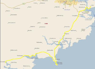
A delightful morning of cycling and after a couple of hours I came to Bere Island and the town of Castletownbere which was about the only town of any size I was to come across until I ended the ride at Kenmare.

Castletownbere, Beara's main town and Irelands largest whitefish port, is a good lunch stop (jeez how slow do these guys go!) with several stores, pubs and resteraunts. From Castletowne its possible to take a ferry to Bere Island. You can cycle the island but accommodation is very limited.

No time to stop or take the ferry across to Bere Island (wasn’t running this early on a Sunday morning) so I kept on cycling heading out to the end of the peninsular.

DunboyCastle makes another nice picnic spot. The ruined 19th Century mansion belonged to the Puxley family who made a fortune mining copper at Allihies. Past the mansion are the remains of a 14th century castle that was the fortress of the O'Sullivan Bere

Though I didn’t get to visit this mansion I did take a wrong turn and end up getting a sneak peek at the gatehouse which looked very impressive. A stark difference from the broken down hovels that most people who worked in the mines would have experienced.

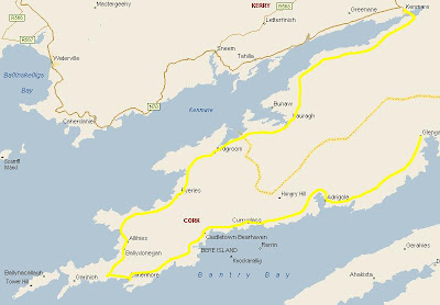
Waterside lushness is left behind in a long climb that ends among giant bolders; the steady gradient and unfolding view make for easy climbing. A final hill affords views of coastal cliffs and Dursey Islan, a haven for wild birds and whales. Visit the island on a side trip (I didnt); its a place to walk or watch wildlife rather than cycle, although there's a tough 8km ride to the cable car that transports locals, livestock and tourists (in that order) across to the island. After the pass, picture postcard views of Allihies are delightful, as is the swoop down to it.

And the village of Allihies

A tough ride through some spectacular coastal and mountain scenery, this stage begins with a punishing roller coaster of short steep climbs. The most strenuous riding is through the striking rocky scenery of the Northern Bera Peninsula. The folds of rock are clearly evident; at times it feels like being on an island of pure rock. Atop the first steep climb the Kerry montains lie dramatically across the water. A short respite comes between Urhan and Eyeries after which some steep ascents and swooping descents lie before Ardgroom.

I also got my first real good glimpse at Kerry with Dingle in the background

The guide book wasn’t kidding when it said there were steep ascents. Having already cycled out the journey back was going to be tough enough with the climbs, to make matters worse just like my previous day of struggling up from Mizen Head this didn’t look like it was going to be any easier with the wind. When I came to some of the more exposed areas the wind was merciless and at time I felt I was going backwards. However I gritted my teeth and dug in.

If you're feeling weary (yes I was bloody knackered) you can avoid the strenuous 15km stretch between Eyeries and Ardgroom (albiet sacrificing views to the Ring of Kerry); take the direct R571 to Ardgroom instead of the coastal road (which I gratefully did as I had enough mileage to cover already).

I didn't miss all the views though

After a glorious cycle I eventually arrived at Kenmare by destination for the weekend. In fact I had done well and gotten here by 2pm which left me plenty of time to get a taxi to Killarney, grab a meal and then take the train home to Dublin

Day 5

Saturday February 25th - Clonakilty to Glangarriff. 91 Miles - Total so far 422 miles

From My Pictures


I need to write a list of things to take with me and be more disciplined. At the last minute before leaving from the apartment on Friday I ditched the waist belt I was going to take with me and instead took my handlebar bag. Only problem was that when I left the office on Friday to catch the train I forgot to pick up 1 of my bottles which had been in the waist belt. Not a huge deal I thought, but boy did I regret not having the extra water carrying capacity today, but I jump ahead of myself.

The train and bus trip down to Clonakilty went without a hitch much to my surprise. I guess I have a very low opinion of public transport so I am always amazed when things actually workout. Susie had rung ahead for me and found a hotel with a good rate. They made me very welcome, which considering how rude some of the people she had rang were, and I soon settled into my room. I had a nice hot meal downstairs in the restaurant and then curled up with my book before getting an early night hoping to god I hadn’t checked into a hotel where my neighbours were going to be from hell.

Apart from the drunken sing song outside in the square at 3am I slept well and was up at 6.30am ready to face the world. Dressed in my super sexy cycling gear (I look like a complete dork) I headed down for breakfast where the chef had very kindly come in 1 hour early just to cook my eggs and beans. With the sun just peeking over the trees and every other sane person sound asleep off I went into the half light of a wintry Saturday morning.

The undulating route to Schull features ancient monuments and stories of more recent history. A pattern emerges of a series of decents into (and climbs out of) townships; the biggest hill, after Ross Carbery, is steep at times. Meadow flowers enliven the roadside, along with the occasional statues of the virgin Mary; Glandore Harbour and The Narrows offer more scenic treats. Towards Schull, Roaringwater Bay and the looming spectre of Mt Gabriel whet the apppetite for the rugged west coast peninsular. The delightful descent into tiny Castlefreke is punctuated by stones explaining points of historical interest. The sprigging school is worth a quick visit; the old schoolhouse now houses a small museum of local history. Watch for the unsigned turn into Castleforke Wood through stone gate posts. A side trip near the top of the climb from Ross Carbery leads to the impressive Drombeg Stone Circle. 17 stones probably arranged around 100 BC. In a nearby cooking trough, hot stones can boil around 320L of water in 18 minutes. Tou'll need to walk the last 150 meters to the site

Needless to say this all passed by me fairly early in the day and keen to get as much mileage under my belt as possible while I had fresh legs I didn’t stop. The morning was clear but my biggest fear today was that my body wasn’t going to be able to cope with the cold. I decided to wear the knee pads that Susie had given me last weekend when I was skiing with her in Sweden and these did a great job of keeping my knees warm. It’s a shame that Richard’s suggestion of using nursing mother nipple pads for my own nipples wasn't as effective. They soon fell off and found there way down south and ended up keeping my belly button company.

Views across the harbour make immaculate Glandore a nice lunch stop; Glandore Inn serves bar food and sandwiches (not at 9am on a Saturday morning I must add). With more choice, including a grocery store (where I restocked with bananas and Oatcake biscuits) Union Hall across the water is more down to earth

In fact Union Hall (apart from having a strange name) was a lovely fishing village with a feel of industry about it even at 10am on a chilly winter morning. It was about the first place I had come across that had much sign of life, most of Ireland was still (very sensibly) sleeping.

The Liss Ard foundations expansive (and very closed) gardens offer a nice resting spot although the gardens are someway from the entrance. Skibbereen was hard hit by the Great Famine; almost 10,000 people were buried in local mass graves

Lament to the Dead of Skibbereen

As I went through the town of Skibbereen it was indeed quite a shock to see the main graveyard with its mass graves. Its hard to imagine just how hard hit Ireland was by the famine. It such a land of such great beauty that such great tragedy should have occurred is very saddening, What is most striking is that it happened relatively so recently.

The Great Famine of 1845-51 was one of the greatest tragedies of Irish history. The disaster was all the greater because, while a million people died and another million fled on overcrowded coffin ships, Ireland continued to export food. The penal laws enacted in 1695 prohibited Catholics from, among other things, entering government and buying land. By the 19th century Irelands population was 4 million. Around 5000 landlords owned 90% of the land, renting it out to Irish tenant farmers. By 1841 the population had rocketed to 8 million. Most were practically subsistence farmers, dependent on potatoes for food and to pay their rent. Many lived in wretched crowded conditions; large families (and their animals) typically shared single roomed virtually windowless cottages (landlords charged higher rent for windows). Rapid population growth meant more pressure on the land and between 1845 and 1851 blight destroyed most the potato crop. Catastrophe was inevitable; without their staple food people starved; without the means to pay rent they were evicted. Even those who grew grain had to choose between eating and being evicted or staying and starving. Those who could scrape together the passage (or whose landlords paid it) left for the New World on overcrowded and unregulated coffin ships on which disease ran rife and typically a third of the passengers died. By 1851 Irelands population was around 6.5 million


I took a break at Schull and enjoyed a cup of coffee at about the only cafe I had seen all day. The view from where I was sitting out over the bay was beautiful especially as the sun was attempting to make an appearance.

Delightful little Schull sits on a harbour of Roaringwater Bay belowe Mount Gabriel. The community is sprinkled with artists and European expatriates and, except during the Summer (particularly early August when the yachties come in) its s pretty relaxed place.

Up until now the day had been very easy cycling and the weather, though cold, very pleasant. However things were about to get a lot tougher and I made a couple of fundamental mistakes. First mistake was underestimating my calorie intake and just how much energy I was going to need to get around Mizen Head and back up to Glengarriff. I had arrived at Schull at about 11am and if I had taken a closer look at the map or maybe made some enquiries I might have realised that Schull was about the last place where I was going to get some food. The next 3 hours were going to seem very long. The second mistake I made was that I didn’t really put much stock in the gentle breeze that had been blowing all day. As it had been to my back I had made good time over the last 60km from Clonakilty. Once I had reached Mizen Head I would be cycling into the wind for about 40km. This in itself wasn't really a problem but combined with the fact that I hadn’t eaten meant I was going to do this when virtually no energy. In other words I was going to "bonk".

To assist ships through the dangerous Atlantic waters a signal station was completed at Mizens Head in 1910. The station was automated in 1993 and an exhibition, Mizen Vision, was established in the old keepers quarters.The light station, at the end of the head, is a 10 minute walk from the Mizen Head visitor center. It costs €5 to walk down and its worth paying; apart from the Mizen Vision exhibition, the scenary is far more dramatic beyond the gate. Look out for dolphins, seals and sea birds. Whales are frequently seen off Mizen head in July and August. A few hills lie between the turn-off and Mizen Head including a 4.6km climb from the inlet near Barleycove beach. The return trip offers spectacular views of the peninsular

The return trip against the headwind and with zero energy was exhausting and as I cranked out each kilometre it was agony on the legs. Every journey no mater how long is comprised of single steps or as in my case single rotations of the wheel and after what seemed an eternity I was at last in view of Bantry Bay.

Exhausted I eventually arrived in Glengarriff where I gratefully booked into my bed and breakfast, had a shower, something to eat and then watched the rugby before falling asleep.

Looking back on the day apart from "bonking" the main thing that was sad was that because of all the time I had lost due to the wind I didn’t have time to do Sheeps Head, maybe another day but I somehow doubt it.

Tuesday 7 February 2006

Day 4

Sunday February 5th - Cobh to Clonakilty. 54 Miles - Total so far 331 miles

From My Pictures


Having done the lion’s share of the mileage yesterday today was going to be much easier. Only problem was the cold was playing havoc with my left knee so I didn’t want to push it too hard in case I injured myself. Up early and after a cooked breakfast was out on the road again at first light. Caught the West Passage ferry across to Monkstown and headed overland to Kinsale.

A longish day mingles inland meandering with coastal dalliance. Traversing Corks undulating countryside the route features Cork and Kinsale Harbours, the lovely beaches of Courtnacsherry Bay and a handful of quiet villages. The journey could be broken at Kinsale, a pretty harbour village, also dubbed Irelands gourmet capital. Its medieval centre makes for a pleasant (and mouth watering) wander

Well don’t know about that but at 9.30am on a February Sunday morning it looked pretty quiet.

Old Head of Kinsale is a promontory south of Kinsale town. Unfortuantely its no longer possible to visit the lighthouse at the end of the promontory: the land is now closed to all but members of the Old Head Golf Links. However a side trip to the castle at the narrow neck affords great views of the coast and countryside on the return downhill run.

One of the highlights for today was the trip out onto Kinsale Head. I wanted to get off the R600 which was pretty busy for this time on a Sunday so was looking for a quieter route. Unfortunately I missed the turn thinking it was further on (yeah I know I should have better maps). Anyway I eventually managed to find the turn and decided to ride out to the very end of "Old Head" as it is known. What a glorious ride through undulating fields passing tumbledown houses and old farms. The very end of the head is a lighthouse and a golf course (which prevents access) and the remains of an old castle. There is also a memorial to the Lusitania which was sunk just off the coast from here with the loss of over 1100 lives. This single event was the reason that America entered WW1 and its so sad to think that such violence should have taken place here considering the beauty of the area. The Wikipedia entry for Lusitania is very interesting

The ride back took me through one of the surfer havens of Ireland at Garrettstown where even at this time of year people were surfing. The sign leaving Garrettstown said "Unsuitable for Horse Drawn Caravans". It should have also have mentioned tired cyclists cause jeez it was steep.

The shallow inlet to Courtmacsherry Bay attracts a wide variety of water birds, some of which migrate from Artic regions. At its head is the village of Timoleague and the impressive remains of its 14th century Franciscan friary

The ride across to Timoleague was very pleasant hugging the coast and drinking in the sights and smells. Actually met a few cyclists out for day all whizzing around and making me look very flat footed. I really wanted to take the longer route from here to Clonakilty but my knee just wasn’t up to the job. Was a shame to "skip" it but I had to be sensible, therefore I arrived in Clonakilty with over 2 hours to wait for the bus.

With plenty of live music, arts and crafts plus the beach nearby, Clonakilty is a lively small town. Most shops and restauraunts are on the long main street known, in different sections, as The Strand, Wolfe Tone Street, Ashe Street and Pearse Street. Restored and old buildings (including several from the linen industry, Clonakilty's mainstay for many centuries) give the place character. Clonakilty's most famous son, the Irish patriot Michael Collins, was born 7km west of the town in 1889

The bus arrived late, was full to bursting, had a drunk singing songs in a very off tone drunken slur, and my bike suffered a broken headlight (beyond repair) but it got me back to Cork in time to catch the Express train back to Dublin. A great weekend of riding but I have to do something about the cold affecting my knees etc

Sunday 5 February 2006

Day 3

Saturday February 4th - Waterford to Cobn. 107 Miles - Total so far 277 miles

From My Pictures


Took the train to Waterford on Friday evening after work and arrived at the B&B at about 9pm. It wasn't the best start to the trip as I forgot both my water bottles in the office along with the address of the guesthouse. Rushed back to the office and was able to get them in time before the train left however I still forgot to pick up the paperwork!.

Only thing of interest on the journey down where the 2 colourful characters who boarded the train the stop before Waterford. If you have seen Brad Pitt in the film Snatch you will know what I mean when I mention Pikeys. These are Irish gypsies who speak with such a strong accent it is almost impossible to understand what they are saying. Well Mr and Mrs Pikey came on board and apart from understanding that he was called "Tam" the rest of what they had to say went completely over my head.

Luckily I had asked the tourist information for a B&B on the Tramore road so after heading that way I easily found it. Didn’t look anything like the photo but still it was clean (though cold) and catered more for the workers in the adjoining industrial estate rather than tourists, certainly at this time of year. Spent the night under a heap of quilts and blankets trying hard not to move too much otherwise they would all fall off my little single bed.

Up before dawn and after a cooked breakfast I was out on the road just as the sky was starting to lighten up. Today promises to be a long day and I am being very ambitious trying to get all the way to Cobn. First stop was Tramore.

Perched on cliffs overlooking a vast Blue Flag beach, Tramore (Tra Mhor) is number one on the family holiday scene and packs out in July and August, when amusements and chip stalls cram the promenade. The town is neat and busy and returns to normality out of season. The 3km long beach is backed by dunes and becomes a great expanse of sand at low tide

I must say it looked a bit different at 8am on a February Saturday morning

The best seaside day in the region follows a cliff-lined shore with a multitude of beaches and coves. Remote surrounds awaken the soul, a cuppa is never far away and the niews are uplifting. Given sunny weather, this day could happily stretch to tow or more. The highlight is the early stretch between Annestown and Bunmahon where the road clings to the clifftop with long views around the coast. The area between Tramore and Stradbally is known at the Copper Coast with several structures left behind from the 19th century mining industry. From the ruined engine house before Bunmahon shafts run 7km underground

Check out an interesting site on mine heritage Copper Coast

This was a very pleasant start to the day. Roads were deserted and I followed the gently undulating coast road. The views out to sea were spectacular and the sound of the surf is something that always gets me in a good mood. I couldn't stop myself from ringing Susie and holding the phone up to the sounds of the ocean

However beaches and coves are the days main attraction. Kilfarrasy Strand is an early side trip. Annestown and Bunmahon are quaint clusters of civilisation where rivers break through to the sea. Numerous coves are signposted en route including Ballydowane and Ballyvooney. Clonea Strand is a popular holiday beach complete with chip and tea stands and a beachside hotel. After Dungarvan the road crosses the Drum Hills and falls to remote Ballyquinn Strand and the popular beach town of Ardmore.

Couldn’t help myself from exploring a bit here (ok I missed the turn) and ended up at Helvick Head. Weirdest bit of road I have across yet, newly surfaced, wide, looking more like a main road and suddenly it ends at a small cluster of houses and a tiny harbour. Having arrived at the end of the world I knew there was a reason for having to come here because lying in the road was an abandoned teddy bear looking very forlorn and dirty. So he is now my cycling mascot and is looking for a suitable name. Arrived in Youghal in time for lunch at Tesco

Youghal. A charming old port at the mouth of the River Blackwater, Youghal (pronounced Y-all) has a long river quay which doubles as the main road to Cork yet remains strangely unspoiled by the jugggernauts. The main street runs parallel to the quayside with painted shops and cafes where seafood is a speciality. The river forms the border between Counties Cork and Waterford.

From My Pictures


After taking a break for lunch it was important to get back on the road and head to Cobh. I really wanted to go as far down as Ballycotton but my left knee was at this stage starting to ache and my nipples were giving me hell from the cold. So instead I did as the book suggested and kept to the minor roads parallel to the N25 and went cross country. I did allow myself one small diversion and hugged the coast around Saleen. After the rather dull cross country route I had been following this was a lovely surprise as I spent a pleasant 30 minutes with the mudflats to my left and dark woodlands to my right. I eventually arrived at the old port town of Cobh and found the hotel Susie had booked for me. Yet again she came up trumps and the 45 Euro was well worth it for a big double bed, warm room, a bath and the fact that the hotel had its own Chinese restaurant with a crackling log fire, I was in Heaven.

Some interesting facts about Cobh. This was the last port of call of the Titanic, there are 115 victims of the Lusitania buried here and most surprisingly this is the town where my maternal great great grandmother O'Niel came from. So there you have it, I am actually part Irish

A very interesting site is one dedicated to the later Father Browne who took the last know photographs of the Titanic
Titanic at Cobh